


Ferienhaus Falzrohr 
Farm holiday in Kastelbell-Tschars/Tschars
Fam. Kaserer Klostergasse 19
M +39 329 1311795 info@falzrohr.com
1 holiday house: 2-4 persons
Our guests love …
- right on Schnals 'Waalweg' along irrigation channels
- detached wooden house with unique views
- Enjoy being alone
Farm with Livestock Fruit growing
Farm's own products:
fruit juice, seasoning, fresh vegetables in season
Farm offers:
Experience everyday life on the farm, Farm tour, Visit to the farm museum
Our guests love …
- right on Schnals 'Waalweg' along irrigation channels
- detached wooden house with unique views
- Enjoy being alone


The farm
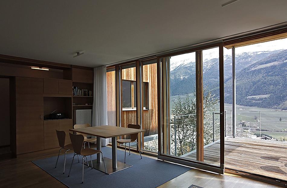
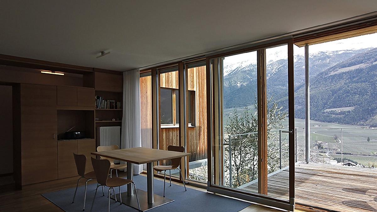
Arrive and feel good, take a break from everyday life here on the farm. A whole house for your dream vacation. Wooden house in a quiet, sunny location.
Daily life on the farm
The Ferienhaus Falzrohr is a farm with Livestock , Fruit growing and Wine growing
- sheep farming (Black-brown mountain sheepJura sheep)
- apple growing (Golden Deliciousother varietiesRed DeliciousRoyal Gala)
- Pear growing (Kaiser AlexanderPala pearsWilliams pear spirit)
- Stone fruit growing (apricotscherriesdamsonsnectarinespeaches)
- Wine growing (pinot noirRiesling)
These animals live on the farm all year-round
poultry
quail
cat
cat
rabbits
rabbits
Things to do on the farm
Farm activities
- Experience everyday life on the farm
- Farm tour
- Visit to the farm museum
- guests can take from the farm garden
We speak German, Italian and English
Holiday flat from 110€ a night
Moments of indulgence at Ferienhaus Falzrohr
Culinary offerings
- apple tasting
Farm's own products
- fruit juice (apple juice)
- seasoning (fresh herbs (depending on the season))
- fresh vegetables in season (carrots, courgettes, lettuce, onions, radishes, tomatoes)
Accommodation & prices
All of our accommodation includes
Holiday house Falzrohr
2-4 persons (4 fixed beds) 60m²
from 110€ for 2 adults
Pets are not allowed in this holiday flat
Description
Our holiday home on the farm combines the best of tradition and modernity. Here you will find many places to withdraw to, relax and enjoy yourself - not only on the sunny terrace. You can also make yourself comfortable in the farmhouse.
General
- garden
- terrace
- radio
- TV
- satellite TV
- WiFi
Bedroom
- double bed
- bunk beds in second bedroom
- Bedding
- solid wood furniture
- wooden floor
Living room/kitchen
- kitchen diner
- solid wood furniture
- wooden floor
- washing machine
- oven
- Crockery and cutlery
Bathroom
- under-floor heating
- shower
- bidet
on request
reserved
we are closed
Location & arrival
Arrival
The Falzrohr holiday home is located on the sunny slope of the parish of Kastelbell/Tschars in South Tyrol. It is located just outside the village of Tschars.
Follow the main road into Vinschgau valley to Tschars, then turn towards the town centre, until Gasthof Sonne, then to the end of Klostergasse.
Follow the main road into Vinschgau valley to Tschars, then turn towards the town centre, until Gasthof Sonne, then to the end of Klostergasse.
Nearby
- distance to village centre1 km
- distance to ski slopes25 km
- distance to cross-country ski run25 km
- distance to sledge run25 km
- distance to cycle path500 m
- distance to bus stop500 m
- distance to shops1 km
- nearest eatery300 m
Ferienhaus Falzrohr
in Kastelbell-Tschars/Tschars lies at
600 metres above sea level.
Activities nearby
Irrigation chanenel path Tschars and Staben
765 m
Uphill Tablander Alm
790 m
Fontana Trail
1,7 km
Church Unsere Liebe Frau in Stava/Staben
3,2 km
Open air pool of Castelbello/Kastelbell
3,5 km
Acquaterra Adventure Club
3,8 km
Lupo Trail
3,9 km
Mountain hut hike at Malga di Marzon
3,9 km
Castle path
4 km
Nature's myths path
4 km
Další statky
Stále hledáte?
Mezi více než 1 600 rekreačními statky v Jižním Tyrolsku jistě najdete ten svůj vysněný statek.